We have taken the following from the official consultation website details at http://www.cambridgeshire.gov.uk/citydeal/info/2/transport/1/transport/6 .
There are very few other details, although there is a background paper from John Grimshaw : http://www.cambridgeshire.gov.uk/citydeal/download/downloads/id/11/the_chisholm_trail_background_paper.pdf
“The Chisholm Trail is a proposed traffic-free walking and cycling route through Cambridge.”
No – the Chisholm Trail is a proposed cycling route. Large sections are not traffic-free either, even if they are on quiet back streets. The trail intends to mix high speed cycling with pedestrians, which is not a happy mix.
“The north-to-south route closely follows the railway line.”
Eerm – sorry it doesn’t. The original route did, but this one doesn’t. We are also baffled why following the railway line is important – surely it would be easier to take the train ?
“This quicker and safer route would be largely off-road or along quiet streets avoiding busy junctions.”
Eerm – chance of any data to say it is quicker and safer ? Quicker and safer than what ? The existing route between the two points is already off-road or along quiet streets and avoids busy junctions. The scheme costs £12.8m so it had better be faster than grease lightning at this price. We have attempted to get figures for the cost-benefits of the scheme, but these are “very complicated” and need more time to compile i.e. they don’t have them. We do know the path is maybe 120m shorter than the existing route from station to station, so that is a mere £100 000 per m in costs.
“The proposals would link up green spaces in Cambridge including Coldham’s Common, the currently private Leper Chapel Meadows and Barnwell Lake area, with Ditton Meadows (as well as Stourbridge Common beyond).”
This isn’t the Brazilian Amazon – there are indeed cycle paths liking all these spaces already. We have no idea what this has to do with reducing congestion, and are rather riled that the best way to enjoy a greenspace is seen as building on it and urbanising it. The trail will have very significant impacts on the wildlife, landscape and heritage of these greenspaces. We asked for some information on the impacts, but this was “very complicated” and needed more time to compile i.e. they hadn’t bothered to consider it.
“The Trail would also connect to the Busway by Cambridge Station and the Busway Extension by the planned Cambridge North Station.”
Fair enough, except it doesn’t. The eastern section does not cross the railway line to reach the station nor can it connect to the Busway further south. The eastern section doesn’t even connect to the Carter Rail bridge to get into the station, but ends in the railway sidings looking for direction.
The western section “connects” across the forecourt of one of the busiest transport interchanges in Cambridge – think Drummer Street with taxis and 100s of train passengers.
The Trail connects at the north end as the guided busway runs into the station. However without a £4m bridge ( starting costs – final costs £8m ) the scheme connects with nothing. This bridge may not be feasible to build and already has a highly convoluted structure that may make it unusable. It depends for its connection to the city centre on a gantry attached to the rail bridge, which Network Rail are likely to refuse; otherwise the connection is about 1.5m wide. Or tunnelling, which would also probably be refused, but if not would be perhaps £2-3m and involve closures of the main line to Ely.
“This scheme would help to reduce congestion in Cambridge by creating a safer alternative route to cross the city. We believe that in order to get more people walking and cycling, more often we need to provide attractive, quick and convenient routes between destinations. This will also encourage less confident cyclists to choose to travel by bike.”
No – this is not true. The scheme is designed to prevent additional congestion from future growth, not reduce existing congestion. The aims of the scheme are very laudable, but investment in Cambridge under the previous City Cycle Ambition scheme cost £5 742 000 and reduced congestion by £5 554 000 i.e. it cost more to build than its benefits. And these were city centre schemes ( see https://www.gov.uk/government/uploads/system/uploads/attachment_data/file/348943/vfm-assessment-of-cycling-grants.pdf for the broad DTR data )
Claims have been made by the council that it will bring a 36:1 congestion reduction – up to £400m in “benefits” – 8 x greater than the £50m figures for the entire new Chesterton station for congestion reduction. This is despite it not being in a major direction of travel for cyclists from the new station and that an alternative to nearly the entire trail exists in a similar format already.
The route is how much safer than existing routes ?
The Chisholm Trail is not such a game changer that commuters will suddenly all switch to a bike, and existing routes are off-road or on quiet streets. Furthermore to get to the Chisholm Trail you will always need to cycle along other routes.
“Complete the online survey by 30 November”
Do it now. Please make sure you indicate that you oppose this present scheme – it is exceptionally badly designed and maximises costs and environmental impact.
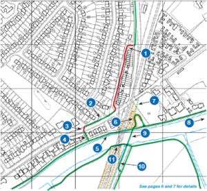
The Route and Chisholm Trail map
The map above is a representation of the proposed walking and cycling route including possible access points. The off-road sections are shown in orange and the on-road sections are shown in purple.
“The Trail would make it easier for students cycling to Cambridge Regional College, for commuters arriving at the planned Cambridge North Station to walk to workplaces south of the river and for workers to travel between the Science Park, Business Park, Addenbrooke’s and the Biomedical Campus. It also links to Leisure facilities like Cambridge Leisure Park and Abbey Pool.”
Let us deal with these in turn :
a. students cycling to Cambridge Regional College – from where ? Unless they live in Fen Ditton, this is not a logical route to take.
b. for commuters arriving at the planned Cambridge North Station to walk to workplaces south of the river – which workplaces south of the river ?
c. for workers to travel between the Science Park, Business Park, Addenbrooke’s and the Biomedical Campus – the distances between these is way beyond British Institute of Transport Engineers recommendations for a cycling commute and certainly beyond walking distance. Surely they would be better off taking the train and then the guided bus ?
“Information about areas along the route including Ditton Meadows, the Leper Chapel Meadow, Coldham’s Common and on-road sections as well as possible improvements to the jetty under the railway bridge and the creation of an underpass for Newmarket Road can be found in the consultation leaflet (pdf, 4.5MB). A Background Paper (pdf, 5MB) developed by project consultant John Grimshaw OBE with further details about the proposals is also available.”
The route on the background paper does not accord with that given in the consultation leaflet; however this is all the information you are getting so you had better read it. There is no information available on costs or the environmental impacts.
“There are opportunities to enhance the Trail through tree planting, public art, habitat creation and the provision of boards with historical and environmental information. We will also look to provide cycle racks and seating.”
We thought this was about congestion reduction and commuting ? It seems to be an opportunity to urbanise some of Cambridge’s wild spaces. Are these core to the project or just an indication of how money is being spent on fripperies ?
“In order to ensure safety, paths next to the railway line in built-up areas will require lighting, other paths e.g. the proposed path along the edge of Ditton Meadows could also be lit, with ground stud lights or low impact down lights. Coldham’s Common is currently lit. No changes to existing street lighting are proposed.”
This was “a safer alternative route to cross the city” remember. Now it is not so safe. The underpasses on the route e.g. at the Leper Chapel, are places that people will avoid in the evening. Ask people if there is an underpass on Barnwell Road if you want to know how well underpasses are used ?
“This is an ambitious project subject to agreement with key stakeholders and landowners including Network Rail, Cambridge Past, Present and Future and Gonville & Caius College. The suggestion of a Trail along the railway line came from Jim Chisholm, a local Cambridge resident and campaigner.”
They didn’t ask most of these people first and several of them dislike the scheme. Cambridge Past, Present and Future called them cavalier.
Sections of the Trail
The Busway, Cambridge North Station to Ditton Meadows
“In Chesterton, the Trail will access the new Station via Moss Bank and join up with the track alongside the Busway Extension Road via a raised crossing point. The existing towpath along the river would be resurfaced and widened in this area.
A new bridge close to the existing railway bridge continues the Trail across the river. Known currently as the ‘Abbey-Chesterton bridge’, this £4.5m project is funded separately and is under consideration by the County Council’s Economy and Environment Committee and subject to a planning application.
The existing narrow wooden jetty under the railway bridge could be replaced with a new 2m wide steel jetty with wing out railing to allow 2.5m of space at bicycle handlebar height. This would not hamper rowing.
A high cost alternative would be the create a tunnel through the railway embankment. Detailed engineering assessment would be needed to see if it is possible to create a tunnel here.”
Let us summarise the above by saying we have no clear idea of whether a properly connected bridge is even feasible, but if it is not then essentially the trail to the south leads precisely nowhere.
The bridge is probably the singularly most destructive item of the trail, and will destroy the landscape character of one of the most charasmatic locations in eastern Cambridge. The footprint of the bridge itself is massive, but a series of switchback ramps add to the urban spaghetti hoops effect. The present design involves two 270 degree turns just to get onto it from the riverside.
The railway line provides a containing feature in the present landscape – a logical breakline to the urban edge of Cambridge. The bridge and its octopus cycleway arms will burst beyond it, both in daytime and by its Blackpool illuminations lighting arrangements at night.
On Ditton Meadows a path would follow the field boundary by the railway line. Works would include: creating a ditch in the area currently beyond the field fence to improve drainage and new fencing.
This is not on the railway line. The 4m wide path will be built on a revetment across the species-rich grazing marsh, and cut across the Stour before destroying wide swathes of additional scrub habitat, which forms a valuable wildlife corridor adjacent to the railway line. The area destroyed supports a colony of water voles.
The Leper Chapel and Barnwell Lake
“The route would follow the stream to the Leper Chapel, Cambridge’s oldest complete building, on land owned by Cambridge Past, Present and Future.”
In fact a Grade 1 listed building, the Leper Chapel and its surrounds are in the category for some of the most important historical buildings in Britain. The council did not bother to consult Cambridge Past, Present and Future or English Heritage before deciding to align a cycleway straight across the doorstep of their chapel.
“A new underpass below Newmarket Road would be needed to ensure a safe and direct crossing for Trail users whilst not impacting on traffic on this key bus route. Given the historical significance of the area the underpass would be carefully designed to reflect its surroundings.”
How nice and thoughtful ! The underpass is probably a cool £1-2m cost and will require closures of Newmarket Road to construct. It may not be technically feasible. It is unfortunately a concrete underpass directly opposite the main door of a Grade 2* listed building. Maybe the right colour paint will allow it to blend in.
The impacts of the scheme on the Chapel are very serious.
The underpass adds an additional 100m and a steep incline to the existing well used and safe pelican crossing. This existing crossing operates after a maximum of 30s and more typically takes 15s to activate. For people travelling in any other direction than up or down the Chisholk Trail, it will be the only option. At night and even in the day, it is likely that most people will prefer this more direct and safer option.
The underpass means a new urbanising bridge and cycle path across the north of the common – eroding the character of this important open space.
“The area around Barnwell Lake has potential to be developed for public access e.g. improved car parking, access for disabled people or even a café, subject to planning permission.”
No it doesn’t – access to this land is wholly substandard being a gate leading directly onto the railway flyover. Okay for anglers. Once the land is developed for a cafe, there will be no restrictions on development for other uses. The cafe is most likely to serve football fans, which will lead to pressure for further development on the common.
Coldham’s Common
“The path across the Common would be upgraded and widened. We are investigating the possibility of lowering the floor of the underpass slightly to increase head room for cyclists. This is subject to discussion with Network Rail and other stakeholders and will need detailed engineering assessment. The sight lines around the existing underpass would be improved. There are opportunities for landscaping, planting and habitat creation in this area.”
Why will it be upgraded and widened ? The council can’t keep the present path repaired, and the existing width is more than adequate.
The route drives straight across the common from Newmarket Road to Coldham’s Lane, at least doubling the width of the existing path, which is wholly unnecessary given number of cyclists and the fact the council seem unable to maintain the current path properly.
Every inch of this land is designated as a County Wildlife Site for its species-rich grassland. It is also common land, owned by Cambridge citizens and not the council, which has been kept open and undeveloped since the middle ages. The council see it as “free” land to grab for infrastructure projects without cost or replacement.
“A new crossing point would be needed on Coldhams Lane. The existing unusual crossing near the end of the bridge cannot be changed, as it is a lorry turning point required to access the Meadows Industrial Estate. We would look to place a crossing point near the end of Brampton Road to prioritise pedestrians and cyclists, with minimal delays to motorists.”
They do not want to use the existing crossing point or existing wide northern verge on Coldhams Lane, but instead create a new 4-5m wide track across the common to a new pelican crossing at Brampton Road. This is almost certainly a prelude to a landgrab off the common for junction widening. We have no idea why anyone would not use the existing crossing.
[Brampton Road is a quiet road, but funnily is not wide enough to be a cycleway – with parked cars it barely reaches 4m. Parking restrictions are likely to follow. The removal of speed humps is also mentioned. ]
Northern city-side section
“The trail splits into sections which follow very low traffic streets either side of the railway line. This side crosses the Beehive Centre, York Street, Ainsworth Street, Hooper Street and the area next to the Mill Road Depot site.”
Southern city-side section
“The southern section of the Trail can be accessed via Cromwell Road or Brampton Road. Access to the proposed path along the railway line on Network Rail land is through the soon to be developed Ridgeons’ site and ajoining Network Rail land next to the railway line. Parking is unaffected although there are opportunities for improvements e.g. road resurfacing and planting.”
Please bear witness to the “parking is unaffected” statement – we doubt it. The scheme will destroy part of the green space and several cherry trees at the junction of Cromwell and Catharine Street, and will require the installation of two zebra crossings at this point.
The railway line
“The path would run through the currently unused arches of Mill Road Bridge on both Northern and Southern sides, avoiding on road hazards. The proposal is for the route to run in-between the railway line and boundary fencing along tracks currently used for works vehicles. In this area fencing and new gates for Network Rail maintenance access will be needed to ensure safety.
The cycleways on both sides of the railway line in this area would be around 4m wide, with occasional widenings and narrowings.”
[They will also be isolated, have no overlooking buildings and be sandwiched between two high security fences. ]
[The route will need to take parts of Great Eastern Street car park and the Argyll Street car park and mature trees here to gain access to Mill Road. Neither of these streets have safe access onto Mill Road, being directly at the foot of the bridge. ]
[The underpasses will be extremely isolated at night, but will be ideal for local rough sleepers to urinate and bed down for the night ]
“On the Southern side a new ramp might be needed to join the Trail to the Carter Bridge. Accesses to the Trail could be created from William Smith Close and Argyle Street.”
Unless you are going to fly a ramp would be very helpful, but unfortunately is mathematically impossible with the available space and gradients.
“The southern Busway and Trumpington Park & Ride are reached across the new Station Square.”
[Good luck with that one in rush hour ! It is also across the station car park]


